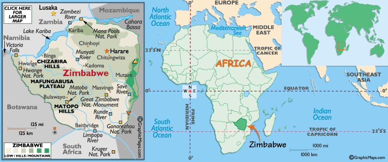
Zimbabwe is a landlocked country
that is located in south-central Africa. It is bordered by Botswana on the west, Zambia on the north, Mozambique on the east,
and South Africa on the south. Zimbabwe’s size is slightly smaller than California, and slightly larger then Montana.
Its climate is tropical savanna, it is moderated by altitude, and also there is a rainy season between November to March. A natural hazard that affects Zimbabwe is the many droughts, floods and severe storm
rarely occur. Other environmental issues are deforestation, soil erosion, air
and water pollution, and endangered species. The terrain is mostly high plateau with higher central plateaus; savanna grasslands cover the southern reaches, while evergreen forests are common central
and east, especially in the mountain areas.
To the east there are mountains such as Mount Inyangani, which is the highest point
in Zimbabwe reaching to 2,592 meters. The land divisions include eight provinces which include Manicaland, Mashonaland Central,
Mashonaland East, Mashonaland West, Masvingo, Matabeleland North, Matabeleland South and Midlands. Also there are two provincial
cities, which are Bulawayo, and Harare. Zimbabwe’s resources include coal,
chromium ore, gold, nickel, copper, iron ore, tin, and platinum groups of metals.
|
 |
|
|
|
|
|
|
Landforms |
Inyanga and Udizi Mountains, Mafungabusa plateau (or Veld), Matobo Hills and
Chizarira Hills anchor that plateau, north and south. Major bodies of water include Lake Kariba, and Victoria Falls. Rivers
include the Zambezi, Limpopo, Runde and Save, and their numerous tributaries. |
|
Size |
390,580
sq km |
|
Climate |
Tropical
Savanna |
|
Resources |
coal,
chromium ore, gold, nickel, copper, iron ore, tin, and platinum groups of metals.
|
|
|
|
|
|